Mapillary for Long Hikes
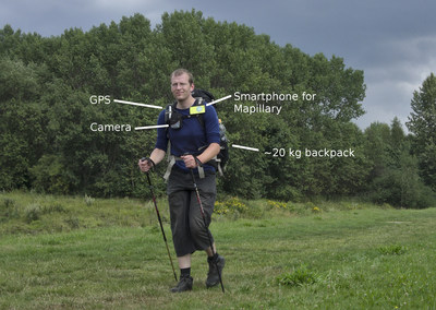
A few weeks ago one of our users, malenki, asked us if it would be feasible to use Mapillary to record an extensive and truly fantastic hike over the course of 10 days in Albania. Turns out it is. He has written a great blog post about the hardware setup.
Here's what the setup looked like:

After the trip, he wrote another post about the aftermath of that trip, going into details of the logistics of hiking and capturing long hours every day.
Data captured
Roughly, this was the outcome of the trip:
- 130,000 photos in total, taken automatically with the Mapillary app on the phone in the forward walking direction
- 110,000 photos remaining after cleanup, of which 7000 marked as panoramas
- 600GB of data sent on a hard drive to Mapillary HQ in Malmö
Processing and uploading
During the trip, malenki had been moving the images off the phone SD card onto a portable hard drive in order to save storage space and do backups. You can find detailed descriptions of his approach to capturing on his OpenStreetMap diary entry.
The files were uploaded with the regular upload script upload.py. Read more about them here.
In this case we did some special treatment with the pano photos and also tried to find a good threshold to cut sequences at natural stops and breaks since the photos were taken continuously and there was no time to switch capture mode.

Some rural hiking with interim panoramic sequences
In urban areas, even just with casual walking you can cover a lot of ground as a traveller.

An impression of the coverage while walking through Tirana
Summary
It is entirely feasible to use Mapillary for recording longer hikes even through bad terrain. There are a number of things that we can do to improve in the future:
- work on better photo navigation to visualize direction changes even within the same sequence (the person moved the camera to the side or turned for some images).
- try a panoramic camera like the Ricoh Theta, mounted on a helmet above the head. This will give nice 360 degree views.
- better tools for editing the information afterwards, with a better Mapillary API for external tools.
All in all - a great success and a good first experiment! Try it yourself. You will get an amazing repository of photos for your trip - easy to share and view!
/peter

